Language
We detect your regional language is French. Do you want to change site's language to French? You may choose other languages.International
 English
 中文
中文
 русск
русск
 français
 español
 العربية


 User Center
 My Training Class
 Feedback


Knowledge application (知识应用)
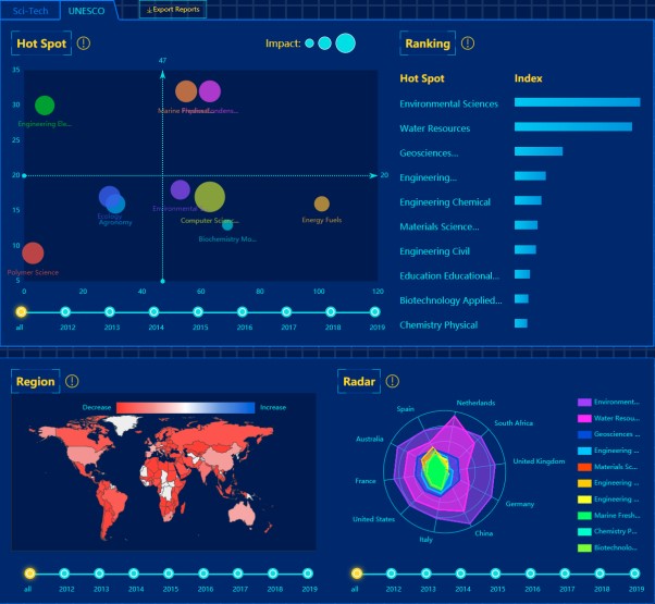
Technology Trending(科技趋势)
Introduction: The Technology Trending, which closely follows the development trends of engineering science and technology focused by UNESCO and IKCEST, accurately orientates the latest scientific and technological information and shares the latest scientific and technological information.
Global Sci-Tech Trend Analysis, centred around the latest sci-tech key words, presents interactive visualisation trend analysis and science and technology trends in terms of temporal and spatial dimensions, research interest and social impact, by integrating various data resources through data mining techniques such as tag association and topic analysis.
UNESCO Focused Sci-Tech Trend Analysis displays UNESCO’s global sci-tech research fields and trends in terms of temporal and spatial dimensions, number of articles published, and number of citations, through data mining techniques such as tag association, topic analysis, and bibliometrics methods.
Personalise Your Sci-Tech Page provides customised technology tracking service to meet the needs of different users for sci-tech trend analysis. Users can track the latest developments and trends of sci-tech key words they are concerned about.
Source: IKCEST General Platform
Release date: Jun. 2020
Provided by: Cai Lingli, Zhang Xinxing
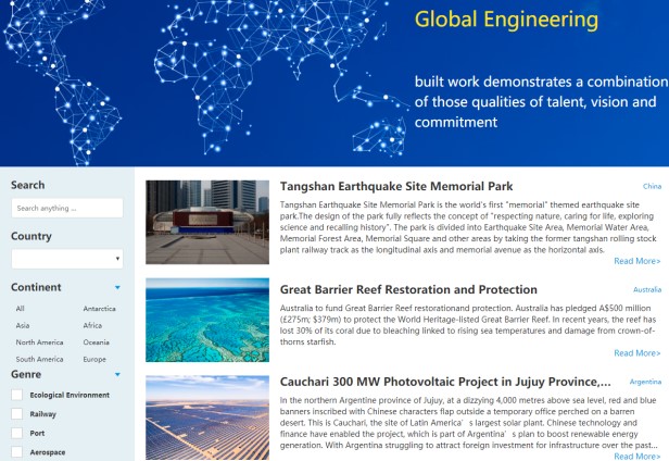
Global Engineering(全球工程)
Introduction: The knowledge service, Global Engineering, brings together on a global scale innovative engineering projects that are representatives of their own regions and fields. Global Engineering offers multi-dimensional classification and search by continents, by counties, and by engineering categories, and suggests associations with related resources on IKCEST platform. The Global Engineering knowledge service mainly provides information related to engineering projects, such as technological breakthroughs, pictures, videos, news, papers and engineering parameters.
Source: IKCEST General Platform
Release date: Jun. 2020
Provided by: Cai Lingli, Zhang Xinxing
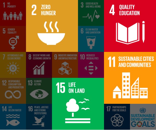
IKCEST Solutions to SDGs(应对可持续发展目标的 IKCEST 解决方案)
Introduction: IKCEST Solutions to SDGs focuses on:
1) SDG 2: Zero Hunger, sharing China’s experience in poverty alleviation through science and technology, such as hybrid rice cultivation and potato planting technology;
2) SDG 4: Quality Education, pooling online video education resources from sub-platforms, academic conference videos, and academic presentation PowerPoint slides;
3) SDG 11: Sustainable Cities and Communities, providing examples for developing countries on the fast track to urbanization and offering support in decision-making to those in urban management, by focusing on cases of intelligent transportation system, urban sewage treatment and more;
4) SDG 15: Life on Land, presenting a Chinese solution to desertification with a focus on technologies and cases of desertification prevention and control, such as sand barriers of straw checkerboard and the Kubuqi ecological restoration project.
Source: IKCEST General Platform
Release date: Jun. 2020
Provided by: Cai Lingli, Zhang Xinxing
Scientific Data (科学数据)
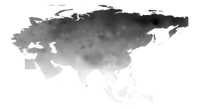
Monthly maximum temperature monitoring data set for The Belt and Road(1989-2018)(1989-2018年一带一路月最高温度监测数据集)
Introduction: The data set is calculated and interpolated by weather station data. The meteorological site data comes from NOAA, which includes data such as temperature, wind speed, and precipitation. The research team processes the daily weather station data into monthly data, and then interpolates through Kriging to form raster data covering the entire study area.
Source: Disaster Risk Reduction Knowledge Service
Release date: Jun. 2019
Provided by: Yuan Yuelei
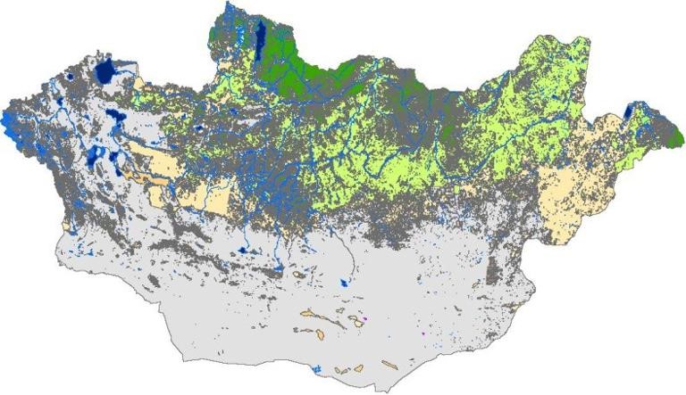
Land use/cover data of Mongolia with spatial resolution of 30m(2010)(蒙古土地利用/覆盖数据,空间分辨率30m(2010年))
Introduction: This data set provides land use/cover data of Mongolia, with the spatial resolution of 30m, using the Albers projection, based on WGS-1984 geographic coordinate system. This data was interpreted on the basis of Landsat TM/etm+ remote sensing image and has 9 first classes including forest land, grassland, wet land, cultivated land, water, tundra, construction land, bare land and snow. The classification accuracy is 82.26% and can be used for the study of land use/cover change in Mongolia, land management, planning and design of urban city.
Source: Disaster Risk Reduction Knowledge Service
Release date: Aug. 2017
Provided by: Yuan Yuelei
Knowledge application (知识应用)
Desertification monitoring in Mongolia section of China-Mongolia railway (中蒙铁路沿线(蒙古段)荒漠化监测知识应用)
Introduction: The China-Mongolia railway, which connects China and Mongolia, is the main cross-border traffic trunk line in China-Mongolia-Russia region and the core foundation of the transportation connection in the construction of the China-Mongolia-Russia economic corridor in the "Belt and Road". The China-Mongolia-Russia economic corridor is characterized by complex natural geography, fragile ecological environment, frequent natural disasters, and serious desertification. By collecting the basic geographical and zoning data, land cover data, and mechanism analysis of vegetation coverage index and different feature space mode, this application discussed the relationship between the inversion model of desertification and land cover and vegetation, and judges the applicable conditions of different models. We obtained the distribution data of desertification along the China-Mongolia railway (Mongolia section) in 2000, 2010 and 2015 with a resolution of 30 meters, and implemented the map visualization application at the front end using the fine print JavaScript library. The application of this knowledge was collected and organized by the Institute of Geographic Sciences and Natural Resources Research, CAS. It has realized the sorting and archiving of the desertification data along the China-Mongolia railway (Mongolia section), completed the analysis of the distribution pattern of desertification in this region, grasped the overall spatial law of the desertification region, and determined the key desertification areas. It can then be used in the research of desertification risk assessment along the China-Mongolia railway (Mongolia section), providing fine and continuous data product support for the prevention and control of desertification ecological risk along the China-Mongolia railway (Mongolia section), and escorting the green and sustainable development of the China-Mongolia-Russia economic corridor.
Source: Disaster Risk Reduction Knowledge Service
Release date: May 2020
Provided by: Yuan Yuelei
Video (视频课件)
Data Sharing and Application of Materials Scientific Data(材料科学数据的数据共享与应用)
Introduction: Materials scientific data sharing network, a scientific data sharing platform in materials science and engineering, is financially supported by the National Science and Technology Infrastructure construction project of Ministry of Science and Technology of China, aiming to collect the nationwide materials data resources and construct the materials data system and data sharing and service platform. In this video, the progresses of materials scientific data sharing network and the application of materials data, one of the three tools of materials innovation, were introduced.
Source: Disaster Risk Reduction Knowledge Service
Release date: 2017
Provided by: Yuan Yuelei
Scientific Data (科学数据)
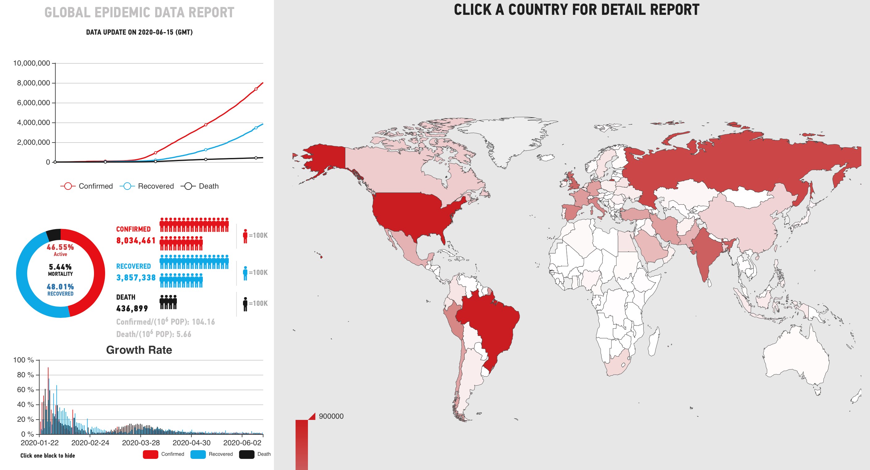
Global COVID-19 Status(全球新冠肺炎疫情数据)
Introduction: The COVID-19 data column shows the statistics of confirmed, cured and death cases in each country under the novel coronavirus pneumonia epidemic situation from January 23rd. Users can also query the cure rate, mortality rate and the daily growth rate of confirmed, cured and death cases in the countries raged by the disaster worldwide.
Source: Intelligent City Knowledge Service
Release date: Jun. 2020
Provided by: CAO Buyang
Knowledge application (知识应用)
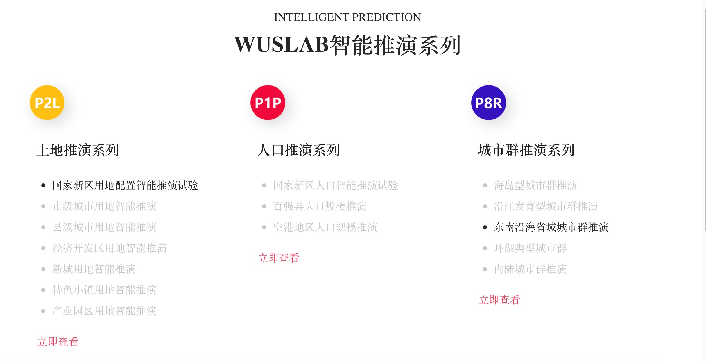
Intelligent Prediction of National New District Land Allocation(国家新区用地配置的智能能推演)
Introduction: The City Prediction knowledge service explores the cutting-edge of AI urban planning, discusses the role of AI in the global industry and urban planning process, and explains how to discover the urban laws with the help of advanced technologies such as deep learning, hybrid intelligence, group intelligence, game computing, etc.. It can better foresee the population, land use, industry, transportation, consumption of resources and other issues contributing to the sustainable development of cities and creates of a better life in the future.
Source: Intelligent City Knowledge Service
Release date: Jun. 2020
Provided by: GAN Wei
Video (视频课件)
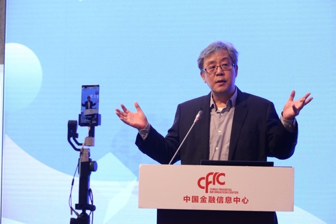
Urban Space Under Pandemic(重大疫情下的空间问题)
Introduction: Prof. WU Zhiqiang is a CAE Member. He serves as the Vice President of TONGJI University, Chair of WUPEN World Urban Planning Education Network. In this lesson, there are five parts, “Spatial essence from the perspective of City Being”, “Space for time to achieve resource allocation”, “The role of urban planning in epidemic prevention”, ”The impact of the epidemic will test the governance of cities”, “Urban governance ability returns to JIAYUAN”.
Source: Intelligent City Knowledge Service
Release date: May 2020
Provided by: LI Xiang
Spatial Synergy and Supportiveness of Public Space (空间协同与公共空间支持)
Introduction: Professor Dieter Frick is from TU Berlin, former director of the institute of urban and regional planning at TU Berlin. In this lesson, the author defined the Spatial Synergy by four parts: spatial synergy, supportiveness, the importance of public space, and how to achieve spatial synergy.
Source: Intelligent City Knowledge Service
Release date: May 2020
Provided by: LI Xiang

Scientific Data (科学数据)
World Development Indicators-Albania(世界发展指标-阿尔巴尼亚)
Introduction: It contains 55 data items from China with data spanning 50 years (1968-2017) and visual display of data, including line, bar, scatter, and pie charts of indicators. It provides all information export functions. It supports Chinese, English, Russian and Arabic language download.
Source: Silk Road Sciences and Technology Knowledge Service
Release date: Jun. 2020
Provided by: Dong Yang

Knowledge application (知识应用)
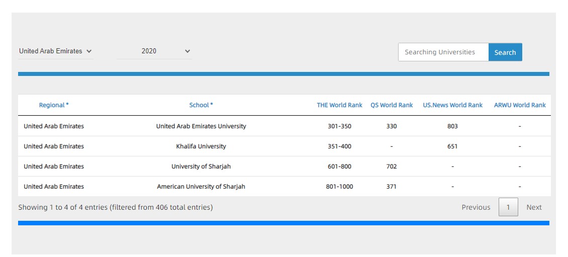
The World Rank of United Arab Emirates United University(“一带一路”高校排名-阿联酋)
Introduction: A knowledge application for comprehensive display and inquiry of Estonia University is built to comprehensively display four internationally recognized world university rankings, such as QS, THE, US News and soft science world university rankings, so as to facilitate engineering and scientific personnel from countries along the " Belt and Road" to recruit students in countries along the " Belt and Road".
Source: Silk Road Sciences and Technology Knowledge Service
Release date: Jun. 2020
Provided by: Zhang Qianglong
Video (视频课件)
Autonomous Driving Car(自动驾驶汽车)
Introduction: As a specific application of Artificial Intelligence, Driverless car, or known as autonomous vehicle, intelligent vehicle, robotic car, has been a hot topic in both academic and industrial field since several years ago, you might wonder “what is a driverless car?”, “how can a car be driverless?” and “when will we have a driverless car?” The course will cover the history, system overview, key technology including perception, mapping, localization, planning, control, different levels of autonomous driving technology, and its current progress and relevant events.
Source: Silk Road Sciences and Technology Knowledge Service
Release date: Jun. 2020
Provided by: Liu Jun
>>>IKCEST Newsletter 2020 April<<<
>>>IKCEST Newsletter 2020 February<<<